Maps, Directions And Trails Conditions
Forest Park stretches more than seven miles of Northwest Portland along the eastern slope of the Tualatin Mountains. The park is open every day of the year from 5am until 10pm. We've developed the following map to help you find your way to some of Forest Park's more accessible trailheads. Click on any of the blue pins below to view additional details or to generate custom driving, biking or public transit directions.
Updates On Current Trail Conditions
The Forest Park Conservancy's staff and volunteers regularly monitor trail conditions and work with Portland Parks & Recreation year-round to ensure the safety and stability of all the soft-surface trails in Forest Park. For current trail closures please visit Trail Closures and Delays on the Portland Parks & Recreation website.
Wayfinding On The Wildwood Trail And Leif Erikson Drive
The Wildwood Trail has been designated as a National Recreation Trail, meanders for 30.2 breathtaking miles, from the southern end of the trail at the Vietnam Veterans Memorial in Washington Park to the Northwest terminus of the trail at Newberry Road. Starting at the Vietnam Memorial/Oregon Zoo, the trail is marked every quarter-mile by blue, diamond-shaped blazes stenciled onto trees about six feet from the ground. The mile markers are located approximately two feet above the blue diamond, and show the distance from the Zoo/Vietnam Memorial trailhead. The Wildwood enters Forest Park proper when it crosses West Burnside St. at about Mile 3.
Leif Erikson Drive, once a road traveled by automobiles and now a wide forest trail, extends 11.2 miles from the NW Thurman St. trailhead to NW Germantown Road. Mileage on Leif Erikson is marked by white concrete posts on the right side of the trail as you travel north from Thurman to Germantown Rd., and show the distance in miles from the NW Thurman St. gate. Read more about the history of Leif Erikson Drive.
Maps of Forest Park
Once you get to the trailhead, you'll want a map to help you find your way through the 80+ miles of trails, fire lanes, and roads inside the park. We recommend these terrific resources.
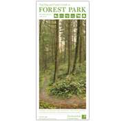
Trail Map and Visitor's Guide to Forest Park
This Trail Map and Visitor's Guide comes in regular and pocket sizes, and is printed on tear and water-resistant paper. A concise guide to the park, this map and guide includes a large relief map of the entire park, user guidelines, and nine recommended hiking and running trails with elevation profiles and information on the flora and fauna you'll see along the way. These are available at our Northwest Portland office (833 SW 11th Ave, Suite 800 in Portland), and at Powell's, New Seasons, and other stores. Please email in advance if you would like to purchase a copy at our office, as our staff are partially working remotely.

Green Trails™ Map of Forest Park
Green Trails™ has been producing quality maps of Forest Park and other notable outdoor destinations for many years. This map of Forest Park also includes Washington Park, Hoyt Arboretum and the Audubon Sanctuary. Includes topographical lines and elevation profiles for the Wildwood Trail. These are available at our office at 833 SW 11th Avenue in Portland and at many local retailers. Please email in advance if you would like to purchase a copy at our office, as our staff are partially working remotely.